Please note - much of the information on GpsMid web pages, especially on development, is outdated - please see the GpsMid wiki for current information.
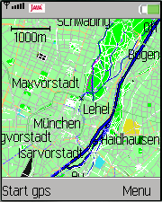
GpsMid is a free, fully offline, vector based map application for your mobile phone. It displays your current position on a zoomable map and can be used to search for and navigate to roads or points of interest of your liking. As all data is stored in a compact binary format on your phone you will incur no charges for extra data downloads.
GpsMid uses map data by OpenStreetMap, a wiki based open source map. Yes, the world is
not really complete yet, but in an increasing number of areas it is starting to be comparable to, if not greatly exceeding, the level of detail found on other commercial maps.
Furthermore, as a wiki, you are always able and invited to help improve it and GpsMid tries to give you the tools to do so. Look at
Getting Involved with OpenStreetMap
for more detail of how to contribute to the map.
Currently supported features:
Vector rendering of the roads, areas and points of interest
Displaying the map either north on top or in the direction of driving
Centering the map to a position received from your GPS:
NMEA GPS-unit with bluetooth connection.
Devices with built-in JSR179 compatible location provider
Version 0.7.3 has been released with many new features
Signed midlets have been released to reduce the constant permission dialogs, courtesy to FOSSGIS e.V.
Limitations
Although GpsMid aims to run on as many devices as possible, due to the large variety of handsets and the sever resource limitations of some of the older mid-range phones, unfortunately not everything works equally well everywhere.
Limited memory: Some phones have very limited memory, such as the Motorola Razr V3 series. On these it may not be possible
to zoom out fully without exceeding available memory. Midlets of about 3Mb size should be fine though, at least
when zoomed in.
Maximum jar size: Some phones, such as earlier S40 phones of Nokia, restrict the maximum size of a jar file they will accept.
As GpsMid typically bundles the map data into the jar, this may limit the area one can incorporate into a single midlet. Support
for storing the data on the file system or as an external zip bundle has been added. This appears to be slightly less robust on some
phones though.
Permissions: Java 2 ME unfortunately has often a DRM policy, which only allows signed midlets to access certain phone features
used in GpsMid. Thanks to the generous support from the German FOSSGIS e.V. we can now offer
such signed midlets. However, this will not work with map data bundled into the midlets and you will need to use external map source
support.
Installation
Pre-bundled midlets are currently provided for a number of common areas. Due to space and processing
restrictions, not all regions are covered though. You can however easily create a bundle for your custom region by yourself. Look
at Osm2GpsMid to find out how to create such a bundle.
Each jar-file is a bundle of the application itself and some map data. Either send the midlet via bluetooth or simply copy it (.jar and .jad file)
to the correct directory on your device. Choose install new and select
the jar file.
Note: Osm2GpsMid runs on your PC not on your phone
Usage
After accepting the initial splash screen, you will
get to the main map screen. By pressing the "fire" button you will get
into the main menu. If you have a GPS receiver or a location aware
phone, select setup
to configure your Location Receiver. Select discover to choose your
bluetooth GPS-device or use the built-in Location-Provider-API
(JSR179), if this is implemented
on your device.
Go back to the
main menu and select Map. After a few moments you should see a map
with your
actual position in the center.
Keys
1: zoom out, 3: zoom in
Arrows and 4,6,8,2 pan the map. Once panned, the map no longer follows your position. To
re-enable centering on your position, hit 5
7 switch through several overlay displays
Hold 9 for a second to enable a key-lock. While GpsMid is running, the normal key-lock will
most likely not activate.
double press 5 to switch between map display modes
Shortcuts to menu entries
* Opens a setup dialog to configure some display options
0 toggles between full screen mode
# Keeps the backlight on even with no key activity
Hold * for a second to jump to the waypoint menu
Hold 0 for a second to toggle track recordings on or off
Hold 5 for a second to jump to the recordings menu
Hold # for a second to jump to the tracklog menu
Double press 7 to upload a new POI to the OpenStreetMap database (Needs an editing enabled midlet)
Double press # to record an audio note
Search location
To find names in the search screen press the number
key with the letter on it once. For example if you want
to search
for otto* press 6886. Initial results are
presented after entering the first two digits. If you see
only null
entries, the names are not resolved yet. Wait a bit and the names
should be displayed soon after. Use the up and down arrow to select an
entry and press the fire button to
jump to this location on the map
screen.
Search for close by points of interest
If you are in the search screen, select nearest POI from the menu. In
the new dialog select which point
of interest you are looking for
and specify a maximum distance. After hitting OK, you should see a
list of
points of interest ordered by distance from the position of
the cursor in the map.
Routing
Select your destination as the target either by searching, or by
navigating the road and select "As target" from the menu.
Once you have selected the destination, go back to your start
position, e.g. by hitting 5 if you have a GPS enabled. The route
will be calculated from the current cursor position to the target once
you hit "Route" in the menu.
Demo
If you have a java plug-in for your web browser, you can have a look at a live demo of GpsMid to see what it offers for you. The page presents a mobile phone emulator that is running GpsMid in which you can try out viewing the map, searching and routing.
Due to starting the java plugin and downloading GpsMid, the demo page might be slow to load!
For security reasons, don't handle this software while driving.